@rumbrummer thanks for thinking along. Very helpfull.
The different U-turns.
sign: -8 u-turn_left:
Left U turn_example.kurviger (684 Bytes)
U turn with often a spacious turntable. U turn command linked to single track point
sign: 8 u-turn_right:
U turn with often a spacious turntable. U turn command linked to single track point
sign: -98 u-turn:
U turn with often a limited turn area. U turn (-98) and Shaping Point do share a common trackpoint.
ONLY this U turn (-98) is able to replace the Shaping Point info and changes it to announced.
U turn (-98) exceptionally so promotes the corresponding Shaping Point into a announced informative one.The standard routing functionality thereby is kept intact as usual by non strict or strict.
The “turn instruction display”, only contains street name info.
This keeps it compatible with the next realization.
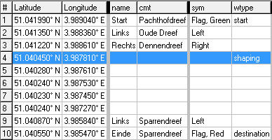
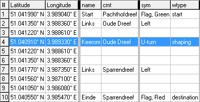
Image examples as trk gpx list.
Shaping Point and straight share a common trkpt.
Shaping_straight.kurviger (1.0 KB)
The not announced Shaping point has priority.
Shaping_straight_trk.gpx (1.3 KB)
Shaping Point and u-turn share a common trkpt.
Shaping_u-turn.kurviger (985 Bytes)
The announced u-turn has priortiy.
Shaping_u-turn_trk.gpx (1.3 KB)
Demo video U-turn: https://youtu.be/CysDm9BwF3I
Apps without shaping points rarely navigate this route flawlessly.
Kurviger navigates this correctly by using the shaping points.

