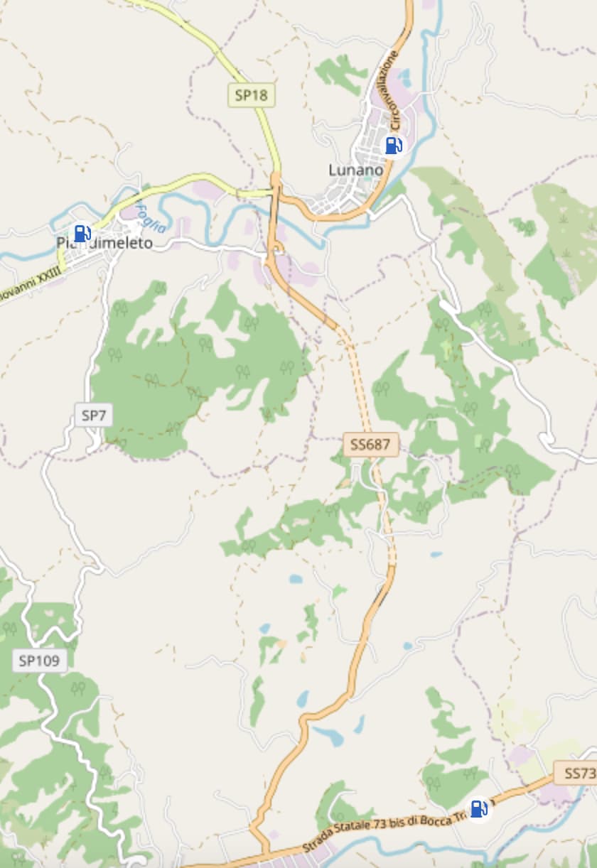
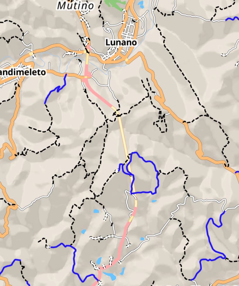
Hi Kurviger Team, I had the opportunity to try Stigra.io and I must admit that their way to hightlight tracks and unpaved roads on the map is particularly useful: if I want to go off-road, their system allows me to set waypoints on the map independently and more easily compared to any map layer currently available on Kurviger because the off-road tracks are quite visibile as they pop up from the map. As an example, I attach a screenshot that highlights the differences: is it possible to emphasize tracks and unpaved roads on Kurviger as on Stigra.io (as a Stigma legend, blue lines are unpaved roads and dotted ones are tracks)?
The closest layer map that Kurviger has, is the OpenStreetMap layer but the lines of the road are so thin and confusing, that it’s impossible di define one type from the other.
Die logische Farbe für unbefestigte Straßen wäre für mich braun.
Ansonsten bin ich auch der Meinung das sie deutlich sichtbarer dargestellt werden sollten
Little typo: it’s stegra.io
You can easily build your own layer using Overpass Turbo.
Create a query with parameters that fit your needs and select an area:
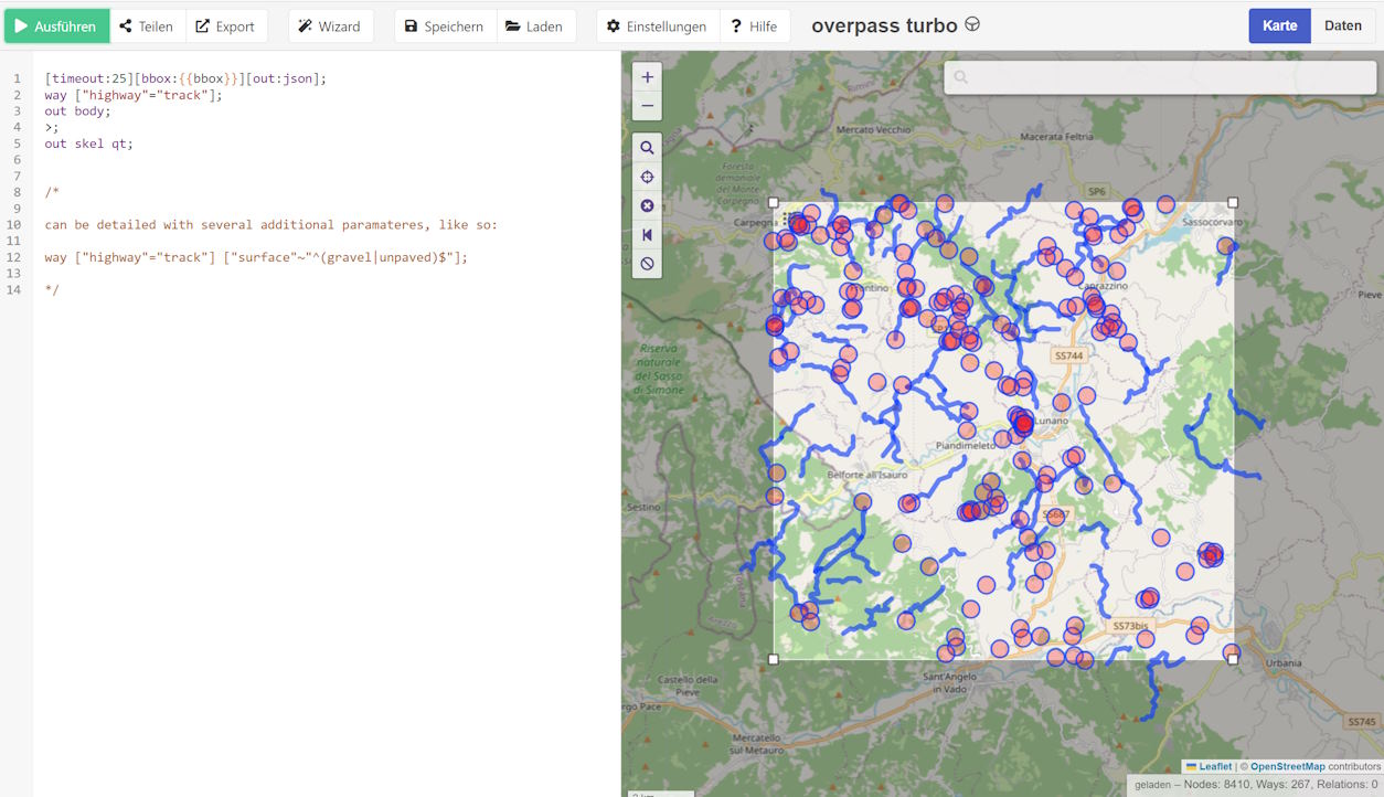
Export the result as GPX, add it as Kurviger Overlay, and select an appropriate colour - e.g., brown, as @grauhaar suggested:

Make adjustments to your query as you like - and you can use multiple query results / overlays with different colours to separate track surfaces.
It takes a little effort, but it’s straightforward and convenient once you’ve set up your queries.
Ja, das würde ich mir auch wünschen … wäre hilfreich im Offroad Bereich.
Auch wenn Kurviger schreibt, sie seien (noch) nicht für Offroud Planung bereit, habe ich diverse und längere Offroad mit Kurviger geplant und gefahren.
Wie machst du die Offroad-Planung mit Kurviger? Mit vielen kleinen Beelines? Oder arbeitest du mit extern erstellten GPX-Dateien und Overlays? Kannst du ein Beispiel (Link zur Route und/oder Screenshot) teilen?
Plane ganz unterschiedlich … Overlay nehme ich auch zur Hilfe, aber erstelle meine eigene Route. Es gibt nur wenige Strasse die eine Sperrung haben obwohl man durchfahren darf, da behelfe ich mir mit der Luftlinie (sind aber eher Ausnahmen).
Hier der Link zu einer gefahrenen Strecke …
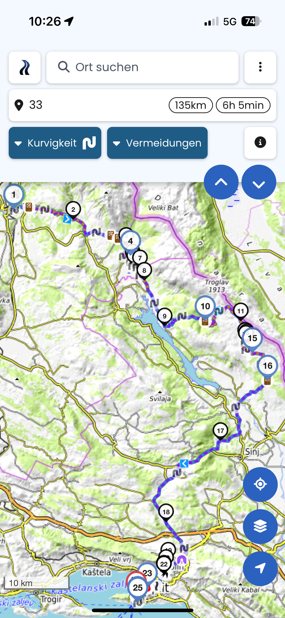
Yes I confirm that the roads with Kurviger are quite fun but, if you plan to go from A to B including only off-road roads, in Kurviger you get a low percentange of off-road roads (2-8% average), on Strigra you get from 30% to 70% of off-road roads: much better from my point of view.
That’s an awesome suggestion Martin and I thank you for bringing it up but unfortunately, as I’ve encountered the same problem on Kurviger, there’s no distinction between unpaved roads and tracks: for OSM they’re the same, as it averages out both identifying them as a generic “off-road” but in Stegra.io, they’re quite distinct and for a good reason.
I’d rather go and have fun on unpaved roads / gravel also during winter but I want to stay away from tracks as being mainly dirt (not gravel), when it rains, they’re a trap for my bike.
Do you know a way to export only unpaved roads without tracks from overpass turbo?
Thanks to MartinW, I’ve found a way to specify the TYPE OF SURFACE I want to see (unpaved but not track) on Overpass.
There’s a Wiki on this:
https://wiki.openstreetmap.org/wiki/Key:surface#Unpaved
I hope this could be useful for some one else, this is the Overpass script, feel free to remove one or more kind of surfaces :
[out:json][timeout:25];
// gather results
(
nwr"surface"=“unpaved”;
nwr"surface"=“compacted”;
nwr"surface"=“pebblestone”;
nwr"surface"=“gravel”;
nwr"surface"=“fine_gravel”;
);
// print results
out geom;
Exactly!
You can play with some parameters and add a CSS (“cascading style sheet”) to your query to separate different results by colour to get instant feedback.
You might want to try this one:
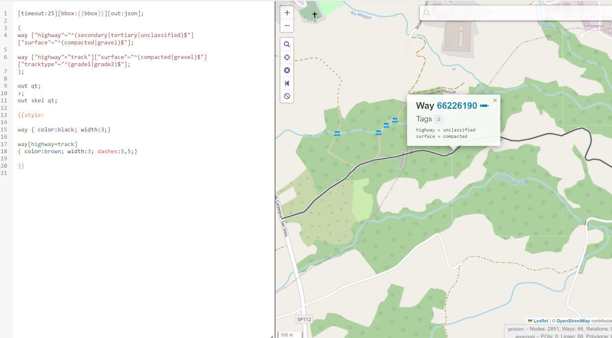
[timeout:25][bbox:{{bbox}}][out:json];
(
way ["highway"~"^(secondary|tertiary|unclassified)$"]["surface"~"^(compacted|gravel)$"];
way ["highway"="track"]["surface"~"^(compacted|gravel)$"]["tracktype"~"^(grade1|grade2)$"];
);
out qt;
>;
out skel qt;

{{style:
way { color:black; width:3;}
way[highway=track]
{ color:brown; width:3; dashes:5,5;}
}}
Clicking on a result will show the parameter values for this particular way:
Unfortunately, this colourization works in Overpass only, and there is no way to split the results into separate GPX when exporting. You can, however, use several queries and address different colours when adding the GPX as overlays.

I’m a novice in the OSM / Overpass world, so I’d love to get more best practices. Please let me know your experiences!
Outstanding job MartinW!!!
I truly appreciate it, a much more clever solution on Overpass, I’ll borrow your code for my exports ![]()
I just wish, when I import the GPX on Kurviger, I could choose lines instead of dotted lines for the overlay track @Team .
In the mean time, thanks again MartinW for opening this Pandora’s vase.
Ciao!
Thank you for that voice.
I realy like K and the way of planning the route.The missing thing is enhanced off-road planning. Would be great to have in some option:
- bolded unpaved roads also in biggerap scale
- Option while planning “UNPAVED ROADS PRIORITY”
That would be v heplful and open platform to other users TET etc.
Thanks.
I am fan of that idea of having tracks and unpaved roads more and better differentiated from asphalt ones in Kurviger map. I have red the alternatives suggested by some members, but it seems difficult an time consuming if you are not familiar with coding. It would be great if Kurviger team could add this improvement on its technical roadmap for 2026. ![]()