An option to determine a start point, combined with a maximum range would be good for me.
I use the expression Lollipop to visualize the drive to the start point & then the round trip.
For example, I live in Frankfurt & want to empty my tank. I don’t want to determine the start point of the round trip - only my home address & my range.
The advantage is, Kurviger can determine the best round trip(s), based on popularity & I just set off from Frankfurt & enjoy the round trip at the end before returning home to Frankfurt.
You could even add some variability - distance to start and end point from home, for example. This would control the distance of the round trip.
I don’t have a good sense of direction or a feel for where to go, so an all-in-one solution would be good for me, so that I can concentrate on the driving & not the planning.
Du könntest so vorgehen:
Angenommen, du wohnst in Frankfurt und möchtest eine Tour von max 220 km machen. Dann suchst du dir zunächst einen Startpunkt, für deine Rundtour z.B. Schloss Wasserlos, es ist ca 45 km entfernt. Hin und zurück sind es 90 km. Es bleiben 130 km für die Rundtour.
Setze nun Wasserlos als Startpunkt und erstellst eine Rundtour mit 130 km, stellst als Richtung z.B. östlich ein, ab in die Hügel.
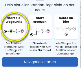
Starte die Navigation. Wähle im nächsten Fenster “Start als Wegpunkt”
und starte die Navigation.
Nun führt dich die Navigation zum Startpunkt der Rundtour. Und wenn du sie abgefahren hast, gebe deinen Wohnort als Ziel an, fertig ist dein Lollipop.
Du kannst nach dem Erstellen der Kurviger-Rundtour aber auch Wasserlos einfach in Google Maps eingeben und danach zum Startpunkt routen. Das hat den Vorteil, dass du möglicherweise schneller durch Frankfurt kommst und die schnellste Route zum Start erhältst. In Wasserlos angekommen, startest du die Kurviger-Route. Wenn du nach dem Abfahren der Rundtour wieder in Wasserlos angekommen bist, kommst du mit GMaps am schnellsten wieder nach Hause.
Und wenn du Glück hast , bleibst du nicht kurz vor Schluss mit leerem Tank liegen!