Obwohl seit 20 Jahren in und um Perpignan, so entdecke ich immer noch wieder neue kleine Strassen in den Pyreneen.So kann man in knapp 2 Stunden vom Sandstrand aus auf den Col d‘Ares fahren, der 1513m hoch ist und auf geradem Weg schon gut 100 Kurven absolvieren. Als Arbeitstier dient mir dabei eine Honda Transalp, die schon 30 Jahre auf dem Buckel hat und deren Tacho mittlerweile 56700km anzeigt, wobei der Tacho nur 5stellig ist!!
Zu meiner zweiten Leidenschaft, den lokalen Speisen, finde ich auch jetzt noch immer wieder kleine lokale Restaurants, wo „Mama“ noch am Herd steht und nach alten Rezepten kocht, braet und grillt, speziell auf der spanischen Seite Kataloniens.
Vielleicht verirrt sich ja der Eine oder Andere in meine Gegend und kann etwas mit diesen Rundfahrten (und Resto Tips) anfangen.
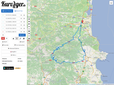
ColAres20190501.kurviger
Von Perpignan aus geht es dem Tet Fluss folgend bis nach Bouleternere, wo es in die Auslaefer der Corbieres geht. Bei Saint Marsal ist man schon auf 800m Hoehe.
Dann geht es weiter ueber Taulis in das Tal vom Tech Fluss nach Amelie-les-Bains, auf 170m Hoehe, einem in Frankreich fuer seine heissen Schwefelquellen bekanntem Kurort.
Jetzt geht es parallel dem Tech entlang immer weiter und hoeher in die Berge. Bei Arles-sur-Tech ist die Strasse schon nach 7km wieder auf 240m Hoehe angestiegen.
Jetzt schlaengelt sich die Strasse dicht gedraengt an der Felswand immer weiter hinauf, 28km nach Prats-de-Mollo-la-Preste auf 740m Hoehe, wo der Anstieg zum Col d‘Ares beginnt, der auch die Grenze zwischen F und SP bildet. Nach 13,5km, dem Col de la Seille 1185m und dem Col de la Guille 1194 erreicht die Strasse den Col d‘Ares mit 1518m Hoehe.
Although I have been in and around Perpignan for 20 years, I am still discovering new small roads in the Pyrenees. 2 hours from the sandy beach you can drive up to the Col d’Ares, which is 1513m high and on a straight road you can take 100 curves. As a workhorse I use a Honda Transalp, which has already 30 years on the hump and whose speedometer indicates meanwhile 56700km, whereby the speedometer is only 5 digits!
To my second passion, the local food, I still find small local restaurants, where “Mom” still stands at the stove and cooks, brews and grills according to old recipes, especially on the Spanish side of Catalonia.
Maybe one or the other get lost in my area and can do something with these tours (and Resto Tips).
ColAres20190501.kurviger
From Perpignan we follow the Tet river to Bouleternere, where we reach the outlet of the Corbieres mountains. At Saint Marsal you are already at an altitude of 800m.
Then we continue via Taulis into the valley of the Tech River down to Amelie-les-Bains, 170m above sea level, a health resort known in France for its hot sulphur springs.
Now it goes parallel to the Tech along and higher into the mountains. At Arles-sur-Tech the road has already risen to 240m after 7km.
Now the road winds its way up the rock face, 28km to Prats-de-Mollo-la-Preste at 740m, where the ascent to Col d’Ares begins, which is also the border between F and SP. After 13,5km, the Col de la Seille 1185m and the Col de la Guille 1194m, the road reaches the Col d’Ares with 1518m height.
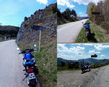
Auf der spanischen Seite verbreitert sich jetzt die Strasse zu einer kleinen Highway, die nur dazu einlaedt, den Gasgriff etwas weiter aufzudrehen.
An Mollo vorbei, durch Camprodon geht es weiter bergab in Richtung Olot;
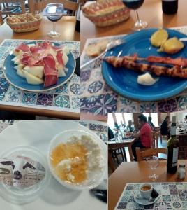
nach 28km kommt man an die Kreuzung mit der N-260 in Richtung Olot/Figueres, wo es durch einen Tunnel von ca 2km Laenge geht (der nicht nur luftmaessig erfrischend sonder sch…. kalt war). Nach weiteren 10km bergab, kommt mein standard Pit-Stop, das Restaurant Mercè (Ca La Gracieta). Bis hierher sind es in etwa 2,5h Fahrt und 130km!
Wochentags gibt es ein Tagesmenu fuer 10€ oder Menu a la Carte ab 15€.
Das hier bekommt man fuer 15€:
On the Spanish side, the road widens to a small highway, which only invites you to turn the throttle a little further.
Past Mollo, through Camprodon we continue downhill towards Olot;
after 28km you come to the junction with the N-260 towards Olot/Figueres, where it goes through a tunnel of about 2km length (which was not only airy refreshing but also f…cold). After another 10km downhill, comes my standard pit stop, the restaurant Mercè (Ca La Gracieta). Up to here it is in about 2,5h drive and 130km!
On weekdays there is a daily menu for 10€ or Menu a la Carte from 15€.
You can get this for 15€:
Zum Verdauen geht es jetzt ruhiger zur Sache, bis nach Figueres und dann nach Jonquera ist nur noch weit geschwungene Highway angesagt. Man kann sogar ein Stueck der neuen Nationalstrasse/Autobahn benutzen, wenn man will, sogar ab Figueres die Autobahn bis nach Perpignan!
Ansonsten kann man entspannt, bis auf das Nadeloehr Jonquera/Perthuis, die Nationalstrasse N-11 und in F die D-900 benutzen.
Alles in Allem ist es eine reine Fahrtzeit von ca 4 ¼ Stunden und 240km nach alter Rechnung, da die Top Speed auf Landstrassen in F auf 80kmh gesenkt worden ist!!
To digest, it goes now more calmly to the thing, down to Figueres and then up to Jonquera only far curved Highway is announced. You can even use a piece of the new national highway if you want, even from Figueres the highway to Perpignan!
Otherwise you can relax, except for the bottleneck Jonquera/Perthuis, use the national road N-11 and in F the D-900.
All in all it is a pure driving time of about 4 ¼ hours and 240km according to the old calculation, because the top speed on country roads in F has been reduced to 80kmh!
ColAres20190501.kurviger (24.2 KB)