I’ve been successfully using Kurviger for several years now. It’s a great tool for planning and navigating backroad road trips through the USA in my camper van.
Anyway I am planning a trip to Germany for 2027 or possibly 2028. One of my friends lives there and we are going to rent a car and visit museums and other interesting places all over the country.
While I am visiting Germany, I am planning to use Kurviger. I want to route our trips through the backroads and avoid highways and motorways as much as possible but I have a lot of questions.
I was wondering what map layer is the most useful. Currently, I use the Standard map layer for my road trips in America, but I see that Kurviger has other map layers such as “Open Street Map” and “Top Plus for Germany and Europe”.
Is there any advantages to using those instead?
How common are unpaved roads in Germany? Here in America, unpaved roads can be a problem in some states, counties or townships but there are other places where the backroads are beautifully paved and well maintained.
If there’s anything else I should know about route planning for Germany, please share it.
Great to hear that you want to use Kurviger as a navigation solution for your trip to Germany
Regarding the map layer: what you use is a matter of taste. The different displays can be helpful, for example, if you want to see the topography better - but the maps shouldn’t have a direct influence on the routing itself.
As for unpaved roads: they are rather rare here in Germany and are mostly used as agricultural and forestry service roads. You can exclude unpaved roads from your route via the avoidance settings, in case you definitely don’t want to drive on unpaved surfaces. Kurviger also shows you during the planning phase if part of your route leads over unpaved roads.
Otherwise, nothing specific comes to mind regarding route planning in Germany that you absolutely need to watch out for. Since you’re traveling by car anyway, you can actually drive on public roads anytime and anywhere - restrictions really only apply to motorcycles.
As I understand it, the map layers are just different visualization options; routing is completely independent of them.
Can it actually happen that there are interactions between the map layer and the routing engine?
As @Guenther mentioned, Germany has just a few unpaved roads that are legally drivable, and you can easily avoid them by excluding them during planning (using the “Avoid” setting).
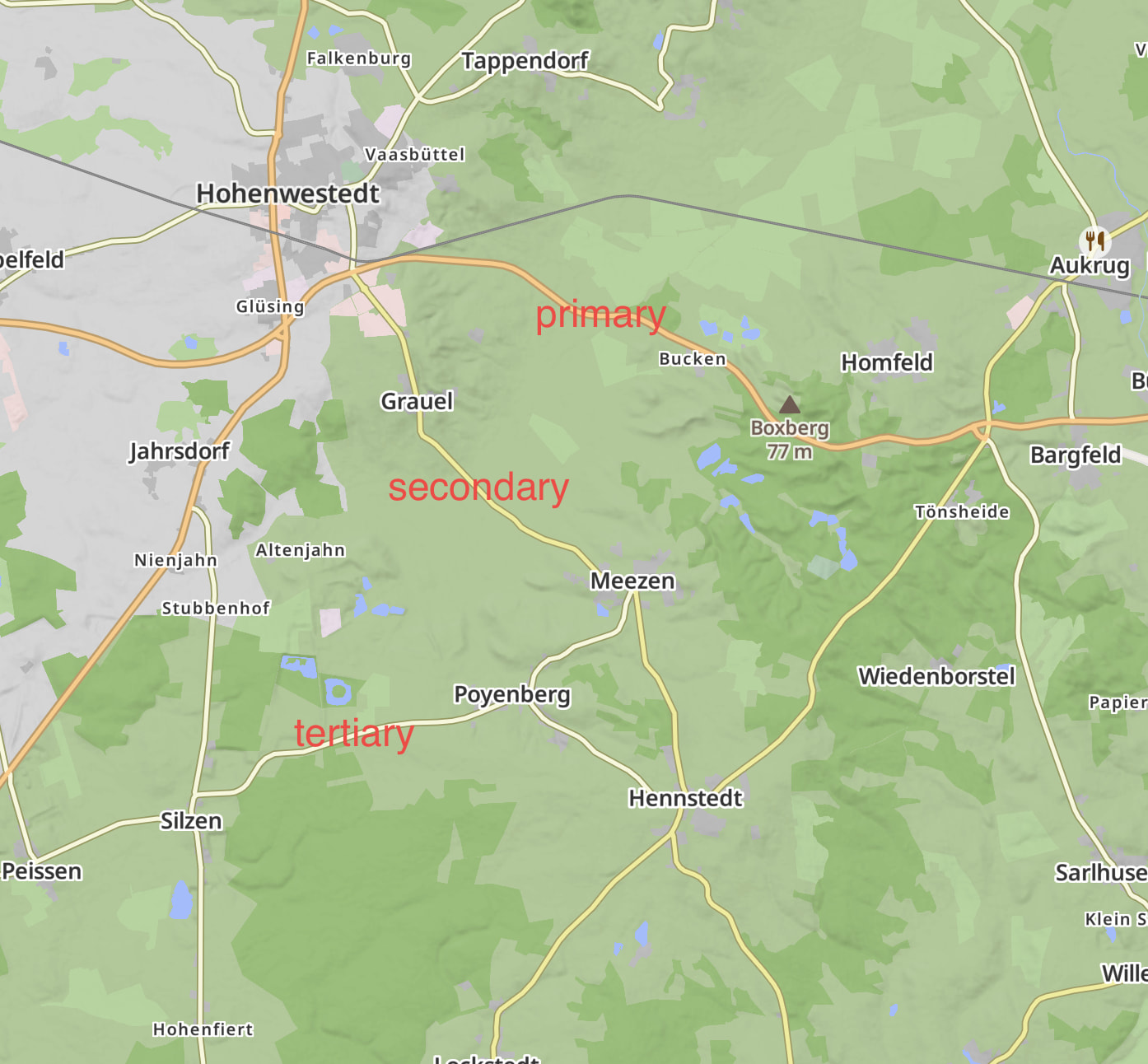
However, many small paved roads in Germany are in poor condition (this varies greatly by state). In my experience, this mainly applies to roads in the “tertiary” category. You can easily identify these by their different colours on the Kurviger Standard Map; here’s an example:
I mainly use the Kurviger Standard Map for planning, but that’s a matter of personal preference
Have fun on your tour of Germany—there’s so much to discover here!