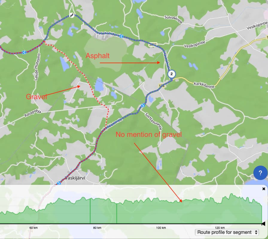
I have used the Kurviger application a few times on the website. After testing a couple of routes, I am puzzled that even though I have strongly excluded gravel roads in the route planning, they still always appear on the route.
In the latest case, the route directed me onto a very narrow forest track (cart path), which was barely rideable.
This is strange, since just a couple of kilometers away there was a paved asphalt road, and the forest track was simply a shortcut to it.
Since I have ended up on gravel roads every time I’ve tested the route planner, I’ve started to wonder whether the software can really be trusted.
Because my motorcycle is a touring bike and it also has a belt drive, I absolutely do not want to end up on gravel roads, let alone forest trails.
On the last occasion, I browsed through the Route information to check if the route contained gravel roads. The route info did not show any, yet this time I found myself in an even worse place than before.
Is there any explanation for this? These routes have all been in southern Finland — are the maps here incomplete?
How do you test these? Do you use the Kurviger app or a third party app or navi?
Kurviger uses OSM data, like all data sets the data is not always perfect. So my first two ideas would be:
If you use our app, then I would ask if you could share 1-2 samples where this happened
If you use a third party navi, my first though would be that often routes can’t be transferred 100% identical, so maybe there are diversions of planned route vs. ridden route.
Most likely the maps are incomplete. In remote areas there are not much people that maintain the OSM data, so gravel roads are often not tagged correctly.
If you share that routes where you encountered described problems, someone from the forum might be able to add the missing tags.
Extra tips:
do not use too much avoidances
If you are riding in remote areas (e.g., Balkans and similar), check the satellite pictures as well
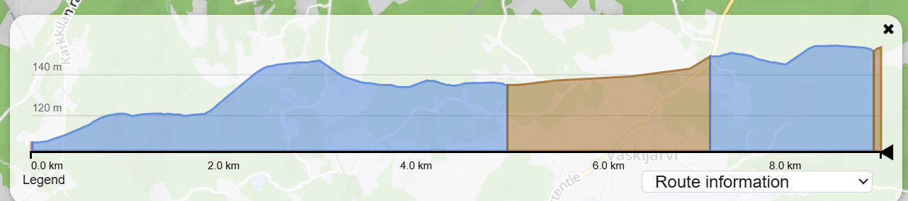
So I understand, this is the part of the Route which is a gravel road:
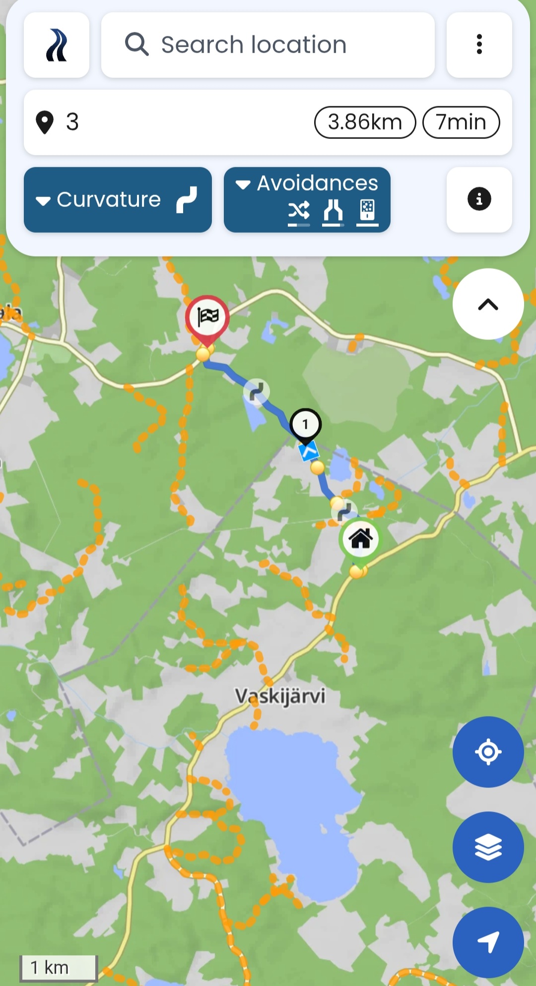
In OSM there is no mention of gravel:
So the OSM should be corrected first - only then Kurviger show it as unpaved road. Is the whole length of this road gravel? You can correct the data in OSM yourself, but if you are unsure how or, someone from the forum could help.
Well, Kurviger is using OSM data as basis, so if a road is not tagged as gravel there, Kurviger has no means to know that it is a gravel road. Of course, you would not check every meter of every route, but in remote areas it is a good practice.
@boldtrn - in the route overview where unpaved roads are shown - could you also display the road where “paved/unpaved” tagging is missing (e.g., with grey colour)? Like you do with speed limits, when they are undefined. This way users would be able to be identify which sections of the route may need to be double-checked.
I mean here, or in a similar view - show as gray area, when the tags are missing:
I don’t know how many of Finland’s roads are paved or unpaved.
However, I would guess that bigger roads are more likely to be paved.
As a workaround, you could try to avoid narrow roads. This should reduce the likelihood of ending up on gravel.
But the real solution is to add the correct surface tag in OSM.
Even though this is about Finland, these places are definitely not remote areas
We are talking about Southern Finland – the Uusimaa region – where 32% (1.8 million) of Finns live. I could imagine that in Northern Finland the maps might have this kind of issues.
But the suggestion is that sections with uncertain data could be marked as grey areas.
Let us know if there are other roads that should be updated.
If you at some point decide to learn how to make changes in OSM yourself - there are plenty of people here that could help you get started. It is not complicated at all - you just need to open an account on OSM and edits like this one are as simple as clicking on a road and selecting a value from a drop-down menu.
The one is about route information, it highlights important information. Where are unpaved roads, where are closed roads, where are ferries or toll roads.
Following the argument that we should show roads with missing tags in gray, we would also have to show roads with no toll information in gray (I’m exagerating of course).
You can see (route information) in the bottom-right.
Hm. I think there are much more untagged unpaved roads then unmarked toll-roads and in my eyes they represent much bigger problem as you can get really stuck in a potentially dangerous situation. But yeah, I hope you can find an optimal solution soon. OSM will not get much better in this aspect very quickly.
@rumbrummer is it possible to make a query in Overpass Turbo and export all (legally accessible) roads where surface tag is missing as GPX file and then add it to overlays? This could also help users with the similar problem as @Staape to identify where a double check for unpaved roads might be needed.
I think, “legally accessible” will be difficult to handle. Searching for several highway types without surface tag is possible, but I have some doubts, if loading them as overlay in Kurviger works.
Edit: With this search you can find highway=unclassified and highway=tertiary without surface tag in the region of your OSM changeset linked above:
Hmmm - I am not sure, if further highway types should be included,so if you do so and choose a larger region, it might cause some trouble.
But I think that has to be tested by users riding in that region - I am just thinking theoretically and might be wrong.