I live in Kirkkonummi near Helsinki Finland and tried to make a simple route to the address Fredrikinkatu 55 Helsinki from my home Veturitallintie 5 Kirkkonummi.
Problem was that the standard map showed all kinds of underground service tunnels etc and handled them as streets. So it was impossible to create a realistic route to my destination.
Previously this has not happened.
What is wrong?
Can you share the link to your route?
Here:
The problematic part is at the end of the route
Your destination is placed close to a service road, so it can be reached only via service roads (in the underground):
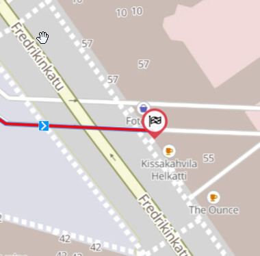
If you place it e.g. on Fredrikinkatu, no service roads are used:
So - from my point of view - this is not a map issue …
Well it surely feels odd, that the router calculates around 500m of the route using a potentially closed road/tunnel, when there is a public road just 5m away from the destination. @boldtrn any hints why would this happen?
Sure, but the app / or map should not use underground service tunnels to calculate routes, or?
In fact I haven´t even noticed these tunnels visible on the map previously.
And Kurviger should also be able to calculate a route on basis of a relevant address as Fredrikinkatu 55?
The “underground service tunnels” are tagged in OSM with highway=service.
This is e.g. a service way for access to a fuel station, parking lot etc.
https://wiki.openstreetmap.org/wiki/Tag:highway%3Dservice
So Kurviger can use it, but gives a warning the warning is due to “access=destination” of some of the service ways.
As far as I know the information tunnel / underground has no influence on routing.
Kurviger (or pretty much any routing engine I know of) will use the closest accessible road to a waypoint for the route calculation.
If you think about it, if you wanted to use that road and Kurviger would always force you on the main road, then the result would be bad as well.