We, 3 motorcycles and 3 riders, took the ferry from Genoa to Palermo. A nice trip; it saves time. A cabin is recommended.
We have been on this trip 13 days, the last day was a long ride home through thunderstorms and icy conditions, about 24°C, which was more then 10° below the most time of the trip.
The shared route was just an idea; we changed a few things along the way. We looked for accommodations in the late afternoon, and that worked very well in early June.
The roads in Italy are fantastic, sometimes even scary.
We changed the option from “curvy” to “very fast” because there are no straight roads in these areas, but even the “mention” of curves leads to very small, single-lane roads. The difference between paved and unpaved roads is only in the size of the loose stones; the number of potholes remains the same.
It was a fantastic trip, very beautiful views, most roads (not curvy) fine to ride, very nice, friendly people, for bikers a very relaxed traffic, everyone makes place, no grumpiness when passing the queue in front of a stoplight or jogging the city traffic along with the scooters.
I will put in some photos and track files when I’m sorted.
3 Likes
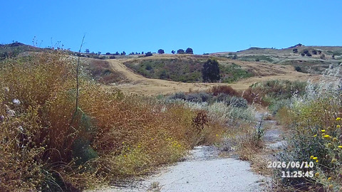
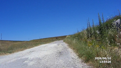
Now the examples of the road, when you just tell “extra curvy” (Pict 1), or “extra curvy” but avoid unpaved (pict 2)
-
IMG_1 ExtraKurvig
-
IMG 2 nur befestigte Strassen
My friends were driving BMW GS, so no problem there, but with my Tuono 660 it was a bit of a struggle.
Those unpaved roads can be a real surprise. I always tweak the route settings to avoid them, especially on a sportier bike.
Yes, but if you just don’t know what the definition of unpaved means. I switched the key for ‘avoid unpaved’ to 5, but still got the road in the second picture.
I love small country roads, I wouldn’t want to miss them, so the tuning took some some time.
Here some examles of unpaved roads.
However, the Kurviger avoidance feature only works when someone has tagged the road in OpenStreetMap.
The road in the second picture is formally “paved”, but I absolutely understand why you might want to consider it as “unpaved”. The correct tag to express the state of the road is “smoothnes” - Key:smoothness - OpenStreetMap Wiki
In this case “bad” would probably be the correct value.
It would totally make sense if Kurviger would avoid “smoothness=bad” if the unpaved avoidance is selected, but I do not know if this is the case. A couple of relevant information can be found in this thread as well: Bad street surface - How can it named in OSM?
1 Like
Yes, that would be a solution to tag it more precisely in OSM, but would Kurviger consider it then as ‘unwanted unpaved’ or would it still be part of my route because it is paved?