Hi, I use Kurviger-App since a few weeks. It’s a nearly perfect app for motorbikes. My respect to the developer, really great work!
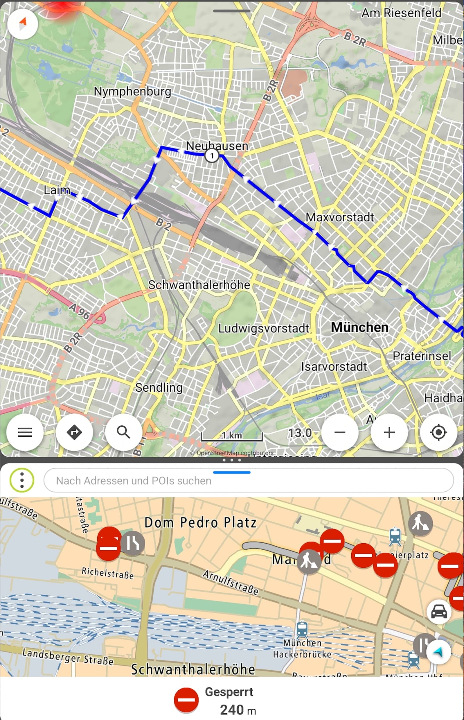
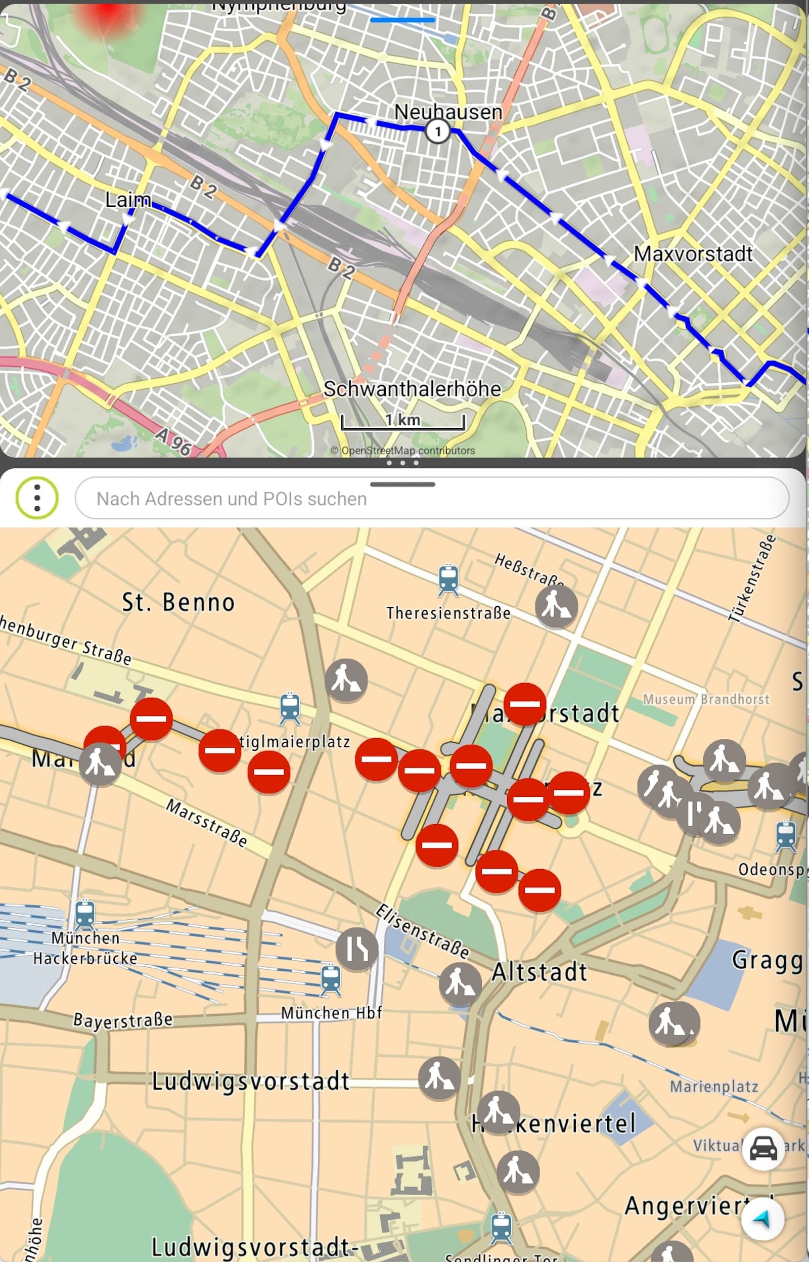
One thing I miss from other devices is actually the display of LiveTraffic or construction site closures. It also happened to me that I came from one road closure (on a country road) to the next road closure and then drove around towns in circles.
By chance I discovered in my BMW-Car (with app “AAIdrive” - on github - is an app that enables Android apps on older BMWs) that MapBox has a Traffic API (https://blog.mapbox.com/traffic-everywhere-5108cb81b403) that shows the live traffic data similar to google traffic .
@devemux86: do you see any chance to integrate this as an additional function or layer?
By now - as a workaround - I export the planned route as track, import it into GMaps (mymaps) and check with the google traffic-layer if there are any current closures/construction sites along the way.
For me it is not necessary to use the closures for calculating the route. It would be enough to see where a closure is and then set two or three new shaping points for another route by myself.
Traffic data is provided and used by routing services and is not free:
“Mapbox Traffic Data is only available through an Enterprise plan, and is licensed annually for a specific geographic region (city, state, or country). Contact our sales team for more information.”
“Data Sharing: Because traffic data relies on anonymized data generated by customers, Mapbox requires that location data generated by an applications powered by traffic data be shared back to Mapbox. For instance, if traffic data is used in a route planning application in the United States, you must share back (in anonymized format) GPS data generated in the normal course of business from the same data.”
No need for traffic data from my point of view. I like road blocks that I can drive through on a motorcycle. It frees up my mind. In 99% of all cases I find a gap to drive through and a bit of gravel on the track doesn’t hurt anyone.
I also usually drive through construction sites and there is usually a way through or over dirt roads around it…but thats only possible on Sundays.
If you drive on a weekday and the construction workers are working there with their machines or the road is just gone or a hole with 2m, then even a Enduro can’t drive throug it.
Or if you’re on a tour with newbies or with Harley riders…and so on…
This is all true and I can certainly understand the desire for traffic data. I’m just saying that it’s unnecessary for me. My day trips are only on Sundays and I don’t drive with novice drivers. I don’t mean that disrespectfully, but factually. All types of motorcycles and drivers have their justification. We drive mainly on adventure motorcycles and pretty much sporty and there are no mimosas in the group or at most 2 times, the first and last time .
Same for me. For motorcycling not necessary.
Less Autobahn and if there is a traffic Spam, then i decide what to do in this case when i’m there.
There realy not many and in most cases i can driv through.
For Long Distance drive on Autobahn, yes a detour will be good.
But i have this only by car!
And if it will happen that i do this on Motorbike, then i will use an App that is progrmmmed to be good for this case (Google, Here we go) and later i switch to the specific App kurviger!
Hallo,
ist es eigentlich möglich sich aktuelle Verkehsstörungen während der Navigation anzeigen zu lassen.
Zum Beispiel Staus ,Sperrungen duch Unfälle u.s.w.
LG Armin
Technisch ja, aber das würde Kurviger nur teuerer machen, weil ein solcher Dienst nicht kostenlos zur Verfügung steht. Das will so gut wie keiner. Der aktuelle Preis ist vollkommen in Ordnung.
Verkehrsdaten basiertes Routing braucht man beim Motorradfahren auch nicht wirklich. Ich finde z.B. in 99% aller Fälle eine Lücke durch eine Baustelle und fahre durch, lustiger Schotteranteil, geht mit jedem Motorrad, auch mit nem fetten Tourer. Und wenn’s mal gar nicht passt, dann sucht man sich halt einen Weg drum herum. Fördert den Orientierungssinn und den Spaßfaktor .
Wenn ich Live Verkehrsdaten basiertes Routing zu kurviger benötige
lege ich mir MyDrive und kurviger auf das Display.
Auf dem Dorf fahre ich oft durch Baustellen
aber in größeren Städten kann ein einfaches drauflosfahren sehr zeitaufwändig werden.
Bei OSMAnd kann man sich die Google Verkehrsdaten als Overlay einblenden lassen. Das könnte auch für Kurviger ein Ansatz sein. Berechnung geht natürlich nicht aber ich kann die Probleme sehen und reagieren.
“(e) No Use With Non-Google Maps. To avoid quality issues and/or brand confusion, Customer will not use the Google Maps Core Services with or near a non-Google Map in a Customer Application. For example, Customer will not (i) display or use Places content on a non-Google map, (ii) display Street View imagery and non-Google maps on the same screen, or (iii) link a Google Map to non-Google Maps content or a non-Google map.”
Hello,
I’m not sure if this is the place, but I would like to renew the discussion about the traffic data. I believe it is essential for any serious route planning app to provide this.
I’d like to point out that Calimoto, for example, has this (provided by TomTom). So I believe it should be in the roam of possibility to strike a deal with some data provider for this. Of course make it subscription only feature. Current road closures etc. is exactly the core navigation feature people expect these days in an app.
The advice to “just split screen with X” is entirely invalid imho. In other thread with speed cameras (also included in Calimoto btw…) there is also this “just split screen with Y” advice.
So for every feature I am supposed to run an extra app? I’m riding a bike, not running my own server room. Most phones already put background apps to sleep or quit them entirely. Already I need to run my bike’s app, music app, navigation and I would like to also, for example, stop and take some pictures. Or open Booking.com. And I have tested, that iPhone 15 quits background tasks (bike app/nav) when opening the camera. On my Samsung S24 there is also a limit of apps that can run in background. Not to mention how will it behave if you also include CarPlay or AA? And you want me to run several other apps for missing features?
And if you have some phone with less memory, the situation would be even worse. Not to mention if you are using wireless charging, since it can only supply limited power.
So I would like to kindly ask to review this again. It’s been years since this topic was created, so the market situation changed and this should be looked into again.
I agree, it would be more than welcome feature, however it is also worth pointing out that Calimoto charges their users roughly double the price of Kurviger, so within these margins they could afford to pay external providers. I personally would still agree to pay couple of Euros more for this feature, but I am not sure everyone would and I am also not sure if Kurviger can so easily adjust the prices of existing subscriptions. So it is likely not just a technical challenge.
How much would that cost and if it would require a price adjustment is just a speculation on our side if Kurviger team does not go and ask the providers about it. And I don’t thing there is a future for Kurviger to compete with all the other moto nav apps (Calimoto, Riser, Strega, Rever, Beeline OsmAnd…) by “We don’t have the features, but we’re cheaper!”
And I believe Calimoto spends their money on Youtuber sponsoring, not on actual development…
I’m personally switching from Calimoto to Kurviger because of the features (routes as layers, stable and well behaved app, reasonable progress in development - not just 2x year “bugfixes” like Cali). And I really like it so far. But if Kurviger were to decide to just fiddle their thumbs and stay still, I would have to start looking elsewhere. Just as I had to do with Calimoto.