Avoid Current Closures | Aktuelle Sperrungen vermeiden

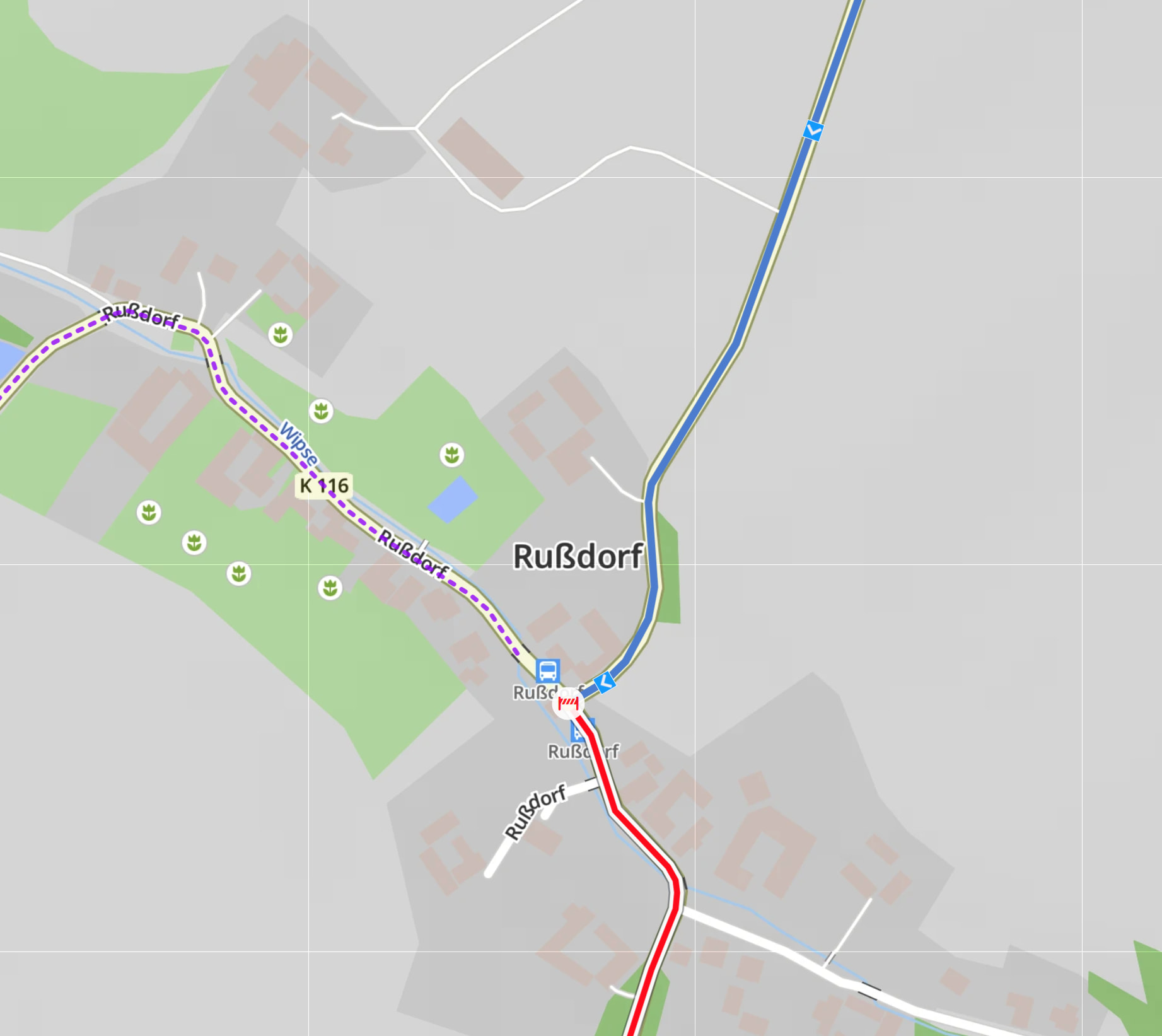
We are excited to announce a new feature on the Kurviger website: you can now see current closures along your route directly on the map, and with a new avoidance setting Kurviger will plan a route around them for you.

No more nasty surprises from construction sites, accidents or other temporary closures during your tour planning – Kurviger now shows you what’s blocked and routes around it automatically when you want it to.

This feature is available with the Tourer and Tourer+ plans.

The next update of the Kurviger app will bring this feature to the app as well. Once available there, route recalculations during navigation will also avoid current closures – as long as you enabled the avoidance setting during planning.

The closure data is provided by TomTom.

Give it a try on our website and let us know what you think! :motorcycle: :smiling_cat_with_heart_eyes: :racing_car:


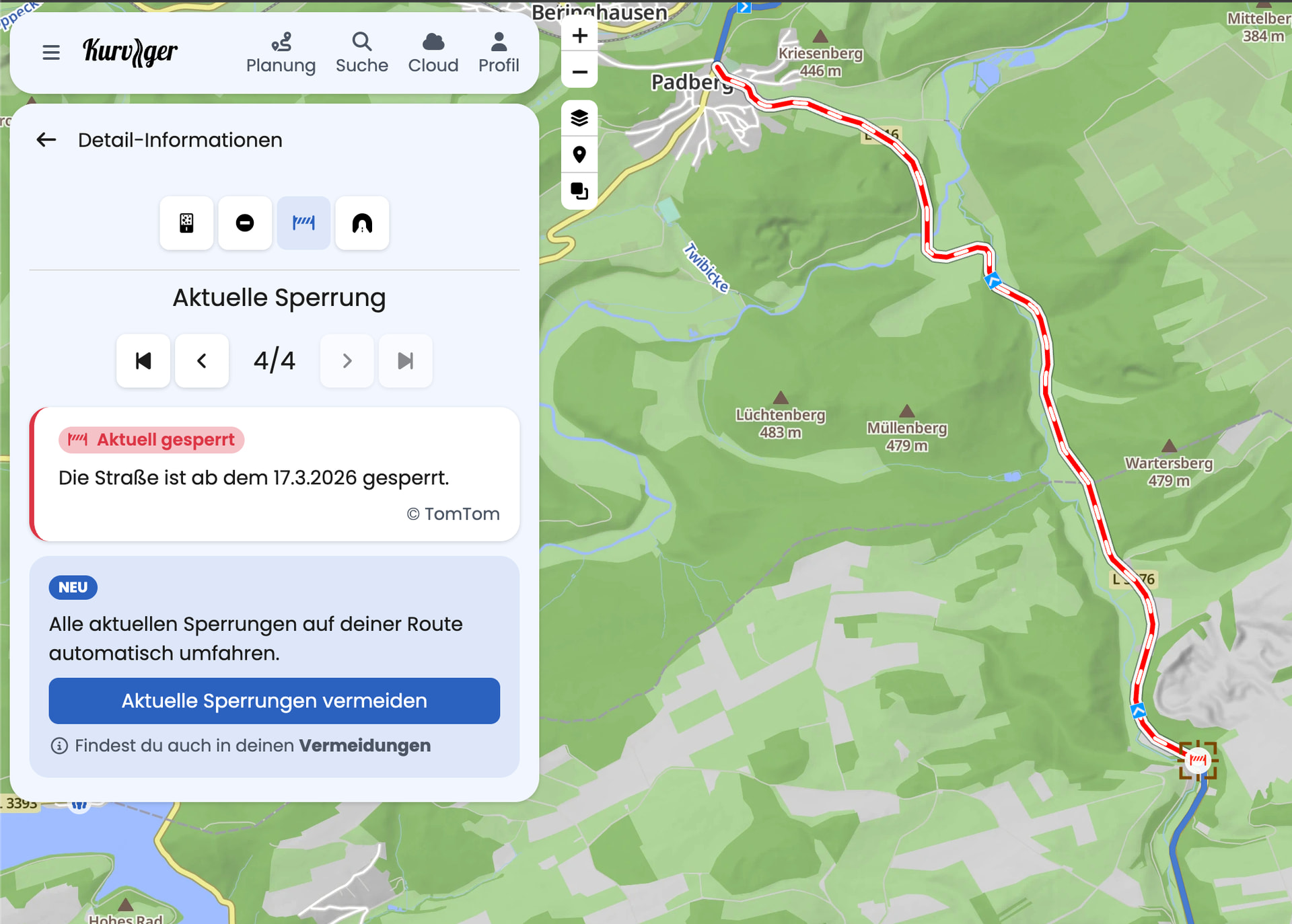
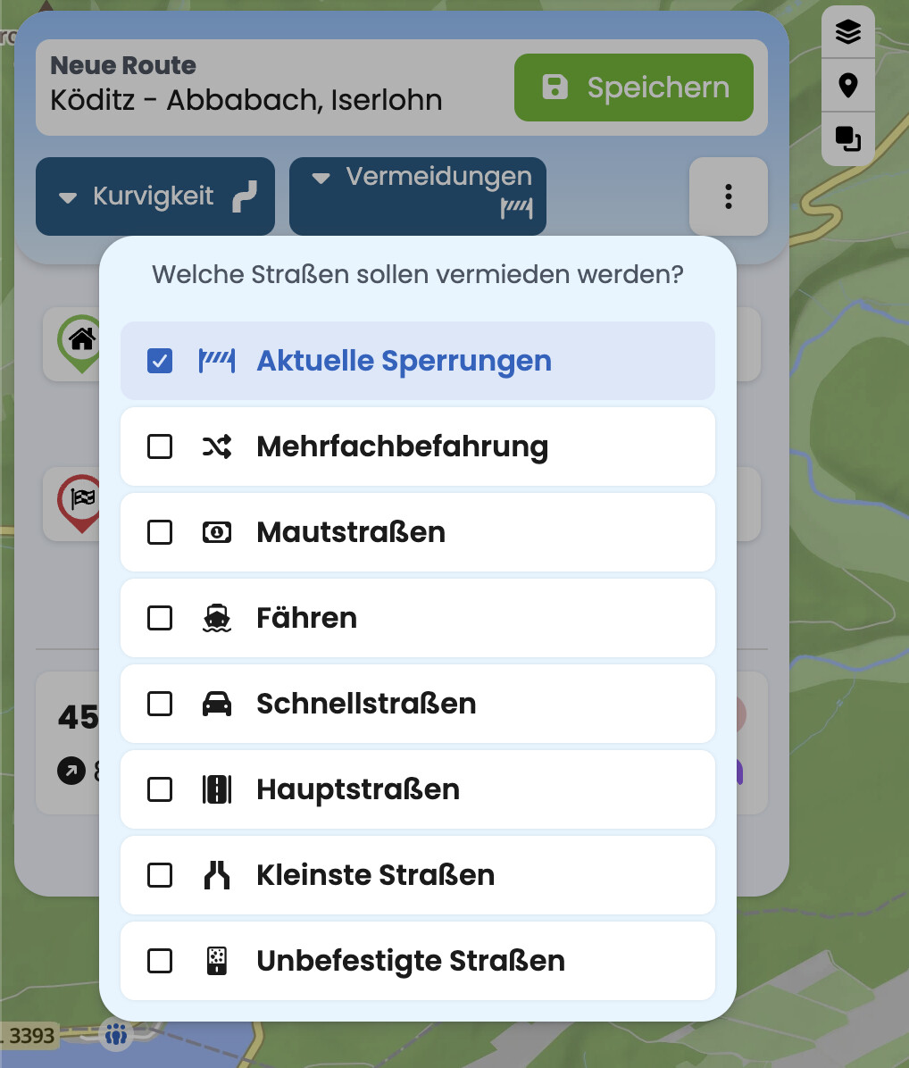
Wir freuen uns, euch eine neue Funktion auf der Kurviger-Website vorzustellen: Ihr könnt ab jetzt aktuelle Sperrungen entlang eurer Route direkt auf der Karte sehen, und mit einer neuen Vermeidungs-Option plant Kurviger die Route automatisch um diese Sperrungen herum.

Keine bösen Überraschungen mehr durch Baustellen, Unfälle oder andere temporäre Sperrungen bei der Tourenplanung – Kurviger zeigt euch jetzt, was gesperrt ist, und umgeht es auf Wunsch automatisch.

Die Funktion ist in Tourer und Tourer+ verfügbar.

Mit dem nächsten Update der Kurviger-App wird die Funktion auch in der App zur Verfügung stehen. Sobald sie dort verfügbar ist, werden auch Routen-Neuberechnungen während der Navigation aktuelle Sperrungen umgehen – sofern ihr die Vermeidung während der Planung aktiviert habt.

Die Sperrungsdaten werden von TomTom bereitgestellt.

Probiert es auf der Website aus und lasst uns wissen, wie es euch gefällt! :motorcycle: :smiling_cat_with_heart_eyes: :racing_car:

28 Likes

Very nice! And you see me impressed by the speed of reaction. I think this was raised as a topic recently and here comes this very useful feature. And I applaud that you reserve it to tourer subscribers, because we want kurviger to continue! :slightly_smiling_face:

Question: If I note a roadblock in the app (once it has the feature), will this be given back to TomTom and thus be available to all others? I hope so. Or have a second database with Kurviger data on roadblocks.

3 Likes

Oooh, this is a nice addition.

I can verify that it’s pretty accurate for Denmark. A road was marked as closed 2 days ago in the web planner, and today it’s marked as open (the road was temporarily closed due to road works for 1½ week ending yesterday afternoon).

Hopefully TomTom will also provide temporary closures due to bicycle races, iron man runs, veteran rallys, and what not happening during the summer. Fingers crossed :crossed_fingers:

2 Likes

Ihr seid die Grööössten!
:heart: Für welche Länder packt Ihr das rein?

2 Likes

Great news. The first trip I used the app on hit two closed roads and it would have been handy to have this option at the time.

2 Likes

I love this idea and I’m looking forward to trying it out, as my standard process was to export a GPX track after planning, and then import it into TomTom to check for any traffic or closure issues! This could be a very helpful and time saving feature!

2 Likes

Thanks for the feedback and the kind words!

Currently, there is no feedback mechanism like this. This is something we do have on our list though.

Das Feature ist “Weltweit” verfügbar, aktuell in knapp 90 Ländern.

Nice. This was very much needed. The only thing here - it seems to me the closures are displayed only when planning the route. Will there be option to actually see that the road is closed just by looking at it? So I can see it is closed without the need to plan a route over it?

2 Likes

Absolutely amazing! Tried it out, looks great so far.

One wish though - always show closures on the map, will make planning so much easier.

2 Likes

Super, gerade ausprobiert. Funktioniert prima :+1:
Vielen Dank!

1 Like

Super, wenn es dann auch in der App verfügbar ist…Perfekt!

Bitte auch beim nächsten App Update an die Tablet User wie mich denken, und das Layout der Infoboxen an das Queerformat anpassen. Dann bin ich wieder happy :+1:

Vielen Dank

Mega. Thanks a lot. Phantastic Feature

1 Like

Hey! Coole Funktion.

Hat mich gleich bei meiner bereits geplanten Route am WE Richtung Gardasee einmal umgeleitet.

So etwas ist Gold wert! Vor allen Dingen wenn sonst den ganzen Weg wieder zurück fahren muss wenn es keine Ausweichroute gibt.

Wenn ich es richtig verstehe und auch aktuell sehe werden auch verlängerte Wintersperren von Pässen nun zuverlässiger bzw. zusätzlich angezteigt.

Beispiel: Hahntennjoch

Normalerweise Nov-April (Standard) gesperrt.

Aktuell aber wegen weiterer Straßenreparaturen bis zum 14.05.26 verlängert worden.

Der Schnee ist schon geräumt. Aber der Pass ist wegen o.g. Reparaturen noch weiter gesperrt.
Auf Eurer Karte wird auch tatsächlich noch eine Wintersperre aktiv von TomTom gezeigt.

Perfekt!

Danke!

Gruß

Stefan

1 Like

Great feature! When available in the app?

Thank you !

1 Like

One button-solution. No big switching on and off map overlays, just planning as normal. Plus, automatic rerouting when it arrives in the app. As far as I know from other apps, that’s not always the case. Many wrote, they would pay more, now for free (for us).
I am impressed. :+1:

3 Likes

We are constantly improving Kurviger, and this feature will continue to be developed as well. Something like that is possible - we’ll keep you updated :slight_smile:

The next update of the Kurviger app will bring this feature to the app as well. So, coming soon!

Cool. Das macht Euren Planer zu einer richtig runden Sache.
ABER es gibt leider einen Fehler bei Eurer Umfahrungslogik. Im folgenden Beispiel müsste man in dem Ort einfach nur rechts statt links abbiegen. Euer Programm definiert die Kreuzung insgesamt als gesperrt.

  1. Ist das nicht korrekt, weil ich die Strecke vor 2 Tagen gefahren bin.
  2. TomTom und Google erkennen diese Sperrungen auch und biegen einfach nur rechts ab, anstatt den gesamten Ort großräumig zu umfahren, um dann aus einer anderen Himmelsrichtung in der Ort einzufahren.
    Ich melde das an Euch, weil ich hier einen Programmier- bzw. Logikfehler vermute, der auch bei anderen Sperrungen passieren kann und das ganz unnötig kompliziert macht.

Leider darf ich nur ein Bild anhängen, weshalb ihr das selbst im Planer mal nachstellen müsst.

Thank you very much!:+1:

But please, please, please keep it as an option. Other planning programs have given me gray hair when trying to plan summer trips in the mountains during the winter. Many passes that are open during the summer will be closed during the winter, which can give you headaches when trying to plan with a planner that takes the closure of a road as a hard fact.

Best regards, Steen

3 Likes

Guten Morgen,

könntet ihr euch mal bitte dieses Beispiel anschauen?

Wäre es hier nicht logischer, dass Kurviger jetzt eine Alternative vorschlägt und den SP umsetzt oder wie bei Sperrungen zu bestimmten Uhrzeiten eine Meldung macht? So ist das beim planen etwas verwirrend, aber sonst ist es echt super, dass es jetzt zumindest angezeigt wird.