Danke fürs Teilen! Das Problem haben wir auf dem Schirm und wird noch behoben.
Last summer 2025 I took a vaccation ride with my bike from Leibnitz/Styria/Austria south to Senj/Croatia via Slovenjia on mostly very tiny paved and very curvy roads. The calculated route lenght was 357km and 6h01min. Which would have meant an average riding speed of almost 60km/h. But this was absolutely impossible to reach on these mostly small and curvy roads with felt thousands of curves on that day. Don´t remember the exact time it took, but it was way over 8hours if I remember correctly. And no I am not the slowest rider…
Has this issue already been corrected? I don´t have that issue using the google maps app. Obviously their route time calculations are more conservative and therefore more realistic.
Has someone of the development team already looked into the route/time calculations algorythm for the various route curve settings?
Thanks for taking notice. Hope this is being improved for the new season 2026.
Hello and welcome to the forum!
If you can share the route described and the GPX- Recording (if you have one), then the team could compare the two and see where the deviations are and how the time estimatio could be improved.
It could be some problem in the algorithm, but more often it is the lack of data in OSM - especially on small roads. The less data about the road is available, the more assumptions the algorithm has to make and those can be wrong.
Comparing with Google Maps… they work on a completely different data basis and and can access user data for their calculations… not sure if it is a comparable App.
Hello and thank you for looking into it. GPX File is attached.
Kitzeck - Senj.gpx (775.4 KB)
Kitzeck - Senj.kurviger (70.2 KB)
Thanks for sharing the files.
Here is what I found:
-
Kurviger does not export timestamps very accurately, still I used them to compare Kurviger speed (above) with your actual speed over the distance. It appears that they roughly match, athough Kurviger appears to be much smoother. This is due to the fact that your GPX contains much more data points than Kurviger exported GPX. Kurviger appears to be slightly faster on average maybe some 10-15%
-
If I look at your speed diagram over the ride duration, then it seems that you took roughly 6 short breaks which amount to maybe 1:15-1:30. If I deduct this from your overall time of about 8:20, I would probably get somewhere slightly below 7h of effective ride time. Kurviger does not account for your ride breaks. The difference between 6 and 7 hours is about 15%. Not perfect, but who is.
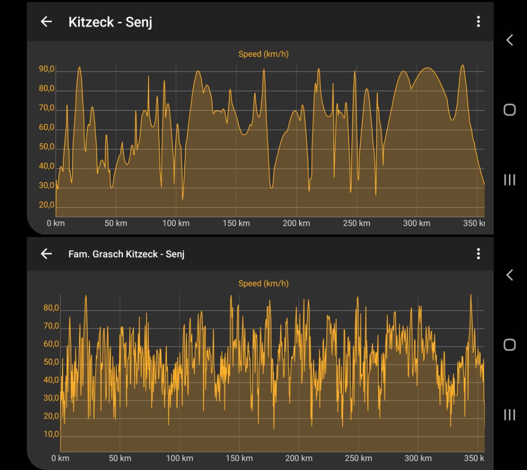
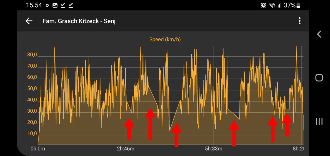
My conclusion - I could not detect a huge errors in the time calculation, but yes, Kurviger is somewhat optimistic in this case.
When comparing estimated and actual times - consider deducting your breaks.
Maybe developers can give better explanation, I am just an amateur. ![]()
When you check the speed limits there are many grey areas = no speed limit maintained is OSM. Then the algorithm must assume.
I check a part and it was a “secondary” (no main road or fast road). This were 132km/2h = 66 km/h. To my experience Kurviger already calculates conservative around 15-20% less than allowed.
My tipp: Check the speed limits in the graphic for grey areas (then in the map in blue). If there are a lot, then double check with your experience e.g. 45-50 km/h.
@RoboMobile this is what is meant with “grey areas” (literally gray on the picture):
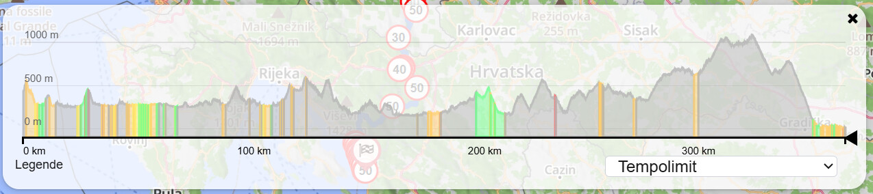
On roughly 80% of your route there is no speed limit data in OSM. I have sample-checked from other sources - some grey sections are actually limited to 50km/h. If there is no data Kurviger would probably assume default speed limit in non-urban area (probably 80km/h in Croatia). This would then cause the difference in estimated and real times.
If you are local and know this route, you could contribute by adding known speed limit data to OSM.
Thank you guys for analyzing my file. The outcome is very interesting for me. I am not local but what I dimly remember is, that in these rural aereas Slovenja, Croatia sometimes on these small tiny sideroads the speedlimit is sometimes above what really is possible, be it the road condition (potholes, gravel, small rocks) or sharp turns hard to see behind.
So what I learned now is the following: The first time calculation of Kurviger is the most optimistic calculation based on given or not given road data. Therefore most likely not the most realistic calculation on some rural routes at first. So I would need to add 15% time in advance. Plus the needed short stops/brakes for eating, drinking and taking a p… over the day.
Quick double checking with other route planning software maybe advised.
That learning and better understanding of the Kurviger software algorithm is of huge value for me for a better tour planning for this coming season.
Thanks for clarification. Enjoy riding in 2026!
Hier ist ein Screenshot von meiner heutigen Fahrt
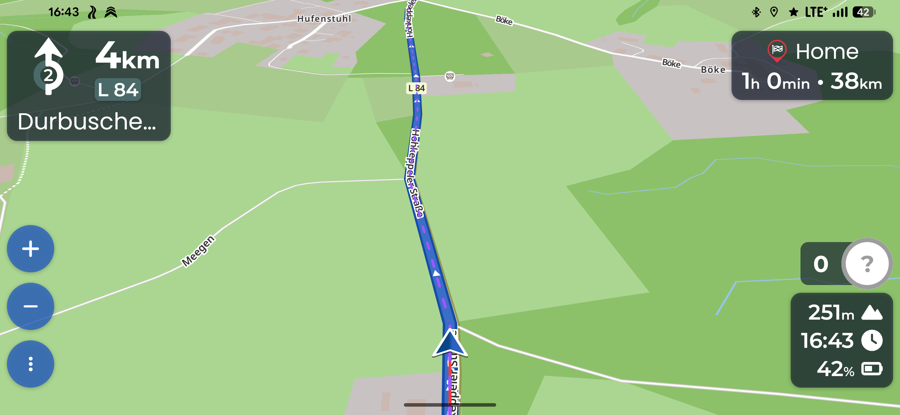
Durchschniitsgeschwindigkeit zu diesem Moment war um 50kmh.
Die restlichen 38Km waren hauptsächlich Landstrasse und etwas Stadt mit 50 und 2 mal 30kmh Strassen.
Sieht man auch im Streckenprofil.
Wie kommt Kurviger auf die 38kmh Vorhersage?
Hier ist die Route. Screenshot wurde am WP2 gemacht
Wielange hast du reell für die 38 km und für die Gesamtstrecke gebraucht?
40 Minuten und es wären noch weniger, wenn nicht ne Stau auf der Autobahnbrücke, wovon Kurviger auch nicht wissen könnte. Also 38kmh ist waaaay off!
nach der Logik könnte ich 20 min (was dann 50% der Fahrtzeit wäre) Pause einlegen, und Kurviger hätte Recht.
So allwissend ist Kurviger auch ned, dass es die Pausen vorhersagen kann:D
Jeder geht immer von sich aus ( oh ich wiederhole mich schon wieder )
Ist doch super wenn ein Tagestripp inklusiv Pausen passt. Hast du Glück gehabt.
Andersrum wärse es doch richt blöd.
Alles sehr knapp berechnet und du hast dann Stau, kleine Panne oder was weiß ich keinerlei Reserven und deine ganze Tour ist nicht umsetzbar. ( passiert ja dann bei Mehrtagestour öfter )
So wie es ist, sind auch die Landschaftsgenießer ( Motorradwanderer ) einigermaßen in der Toleranz.
Ich für meinen Teil weiß, dass ich schneller bin wenn ich alleine fahre. Bzw. in der Gruppe mit den nötigen Pausen dann sogar ziemlich genau so lange brauche.
Also perfekt.
Das einzige Problem: Da man individuell fährt muss man auch individuell darüber nachdenken und seine Schlüsse ziehen.
Und wer mir erzählt, dass xy die Zeit perfeekt berechnet, soll glücklich damit werden.
Auch das so viel gelobte Google passt bei mir nicht.
Wie auch, kann weder meine Fahrweise noch meinen Fahrbaren Untersatz vorhersehen.
Sorry, aber dafür muss man nicht in der Lage sein vorausschaubar zu denken!
Wenn ich ne Strecke plane, will ich die Fahrzeit wissen. Meine Pausen plan ich selber, ich brauche keine Pi-mal-Daumen von Kurviger dafür. Ich kann für mich selber denken. Und Staus kann Kurviger sws nicht oder noch nicht.
Es war schon nervig, dass wenn Kurviger mir für ne Tagestour 6h zeigte, ich aber nach 4 fertig war.
Aber viel nerviger ist es, wenn es nur um 100 km Strecke geht.
Probier mal in anderen Routing- Engines (ich habe es nicht gemacht, mache ich manchmal, wenn es mir komisch vorkommt).
Calimoto, Brouter, Graphhopper, OpenStreetmap, Organic Maps (da finde ich persönlich Berechnung sehr gut).
Danke, Kurviger find ich schon am besten für Bikefahrten. Cali z.b. ist der letzte Schrott.
Und die komische ETE ist kein Ausfallkriterium, sage nur, dass es Verbesserungsbedarf hat.
Und mich triggert, dass manche Leute denken, dass reiner Zufall, dass deren Fahrten mit PAUSENzeit ähnlich der ETE sind, was gutes ist. Denn es ist reiner Zufall, nichts mehr und nichts weniger. Und evtl noch Placebo Effekt:)
Faustformel 10-20% zu lange ist es meist. Man hat Abbremsen, Beschleunigen, auch mal Ampeln. In Ortschaften oft nicht erlaubte 50 möglich. Bei mir passt das meist. Wenn längere Tour, dann ist auch ne Pause drin.
Wenn es viel länger geht, dann kontrolliere ich auch mal, wenn es um Übernachtung geht.
Lösche mal alles bis zum WP2, schalte alle Vermeidungen aus und schalte die Vermeidung der Hauptstraßen. Das ist nicht die gleiche Route, aber ein interessantes Ergebnis ist das schon, oder?
Nein, ist kein interessantes Ergebnis, denn es ist eine fast komplett andere Route jetzt.
Also man kann das doch nicht vergleichen. Dass die Zeit passt, ist schon wieder ein reiner Zufall!
Hab ich doch als ersten Satz geschrieben. Jeder geht von sich aus. Hast du damit bestätigt.
Eine Software kann die Zeit für dich nur dann treffen, wenn sie genau auf dein Fahrverhalten (hoffentlich fährst du immer gleich!) programmiert wurde.
Dann ist sie aber für viele ander überhaupt nicht zu gebrauchen.
Deshalb hab ich erklärt, dass es aus meiner Sicht ein guter kompromiss ist.
Und wenn du für berechnete 6h dann 4h brauchst, kommt mir der Gedanke ob du dich an die Begrenzungen wirklich hätlst! Das soll kniemals irgendeine Software berechnen! ( Meine Meinung)