When exporting a GPX file, I can choose between Waypoints Route and Track.
However, if I only want to export just via points, I have no option to select this.
Would it be possible to add this option?
Just for my curiosity - for what reason is this option needed? Would it be a feasible solution to eliminate all shaping points and create the same route solely consisting of few as possible via points?
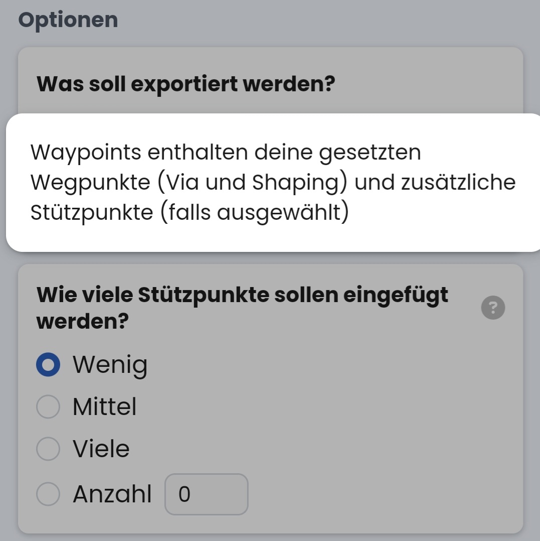
If Waypoints is selected during export, only all waypoints from the route are exported additionally in the wpt section. This category is actually used to define additional waypoints outside the route. For example, to show potential overnight accommodation. In my opinion, this functionality is not available in kurviger.de. Therefore, exporting a waypoint list is useless. See:
On the other side selecting Waypoints when importing a .gpx file with definitions leads to the calculation of a ridiculous route in kurviger.de, which is not the point at all.
Here an example (a short TET file): P.gpx (586,9 KB)
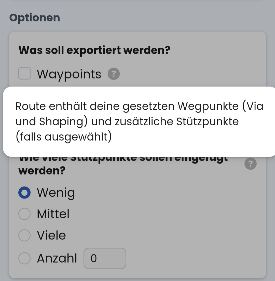
A route created or edited in kurviger.de contains all waypoints (via and shaping) in the section and should do so - omitting the shaping points would result in a completely different route.
Are you suggesting to add a command “delete all shaping points”? That might be a useful option when creating a new route from one or more existing tracks. You could “promote” a couple of shaping points to via points and clean-up (delete) the rest using just one command.
The reason is quite simple…
Let’s take the BMW Connected App or the BMW Connected Ride Navigator.
I also plan routes for my colleagues, who also prefer other navigation solutions, such as Garmin or the BMW Connected App.
The BMW Connected App can “only” process 50 points (regardless whether via or shaping), anything beyond that is just a track.
My idea is as follows…
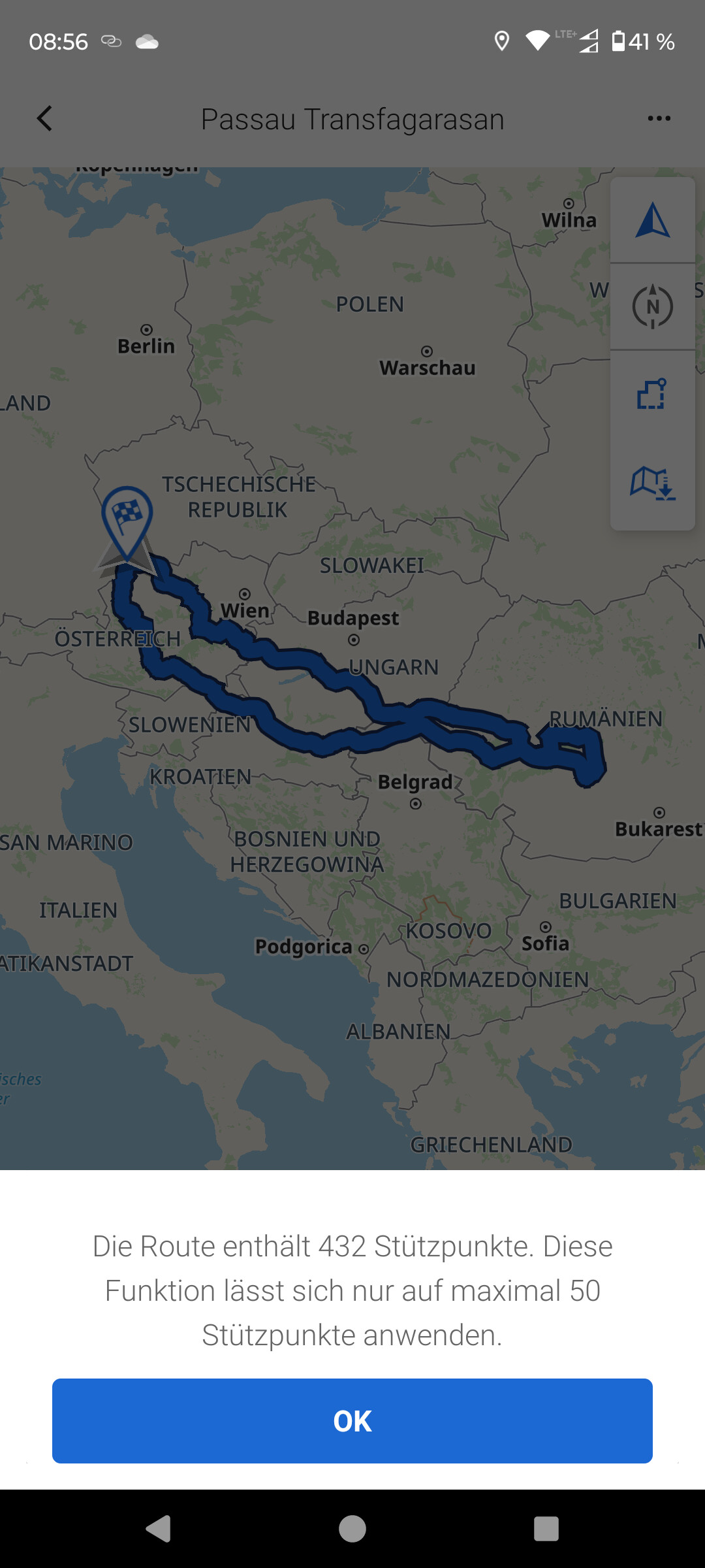
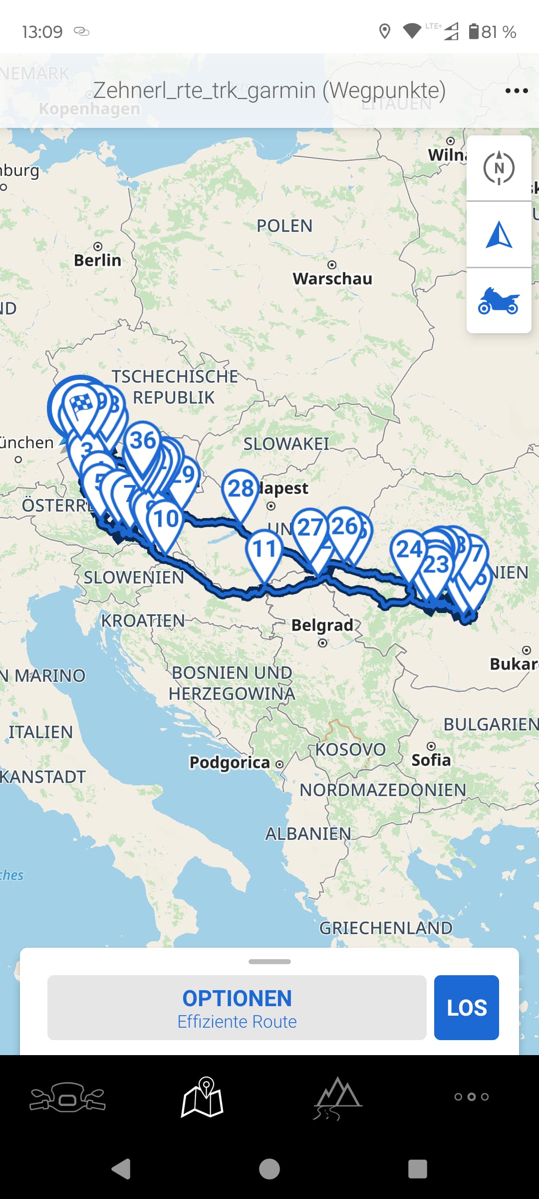
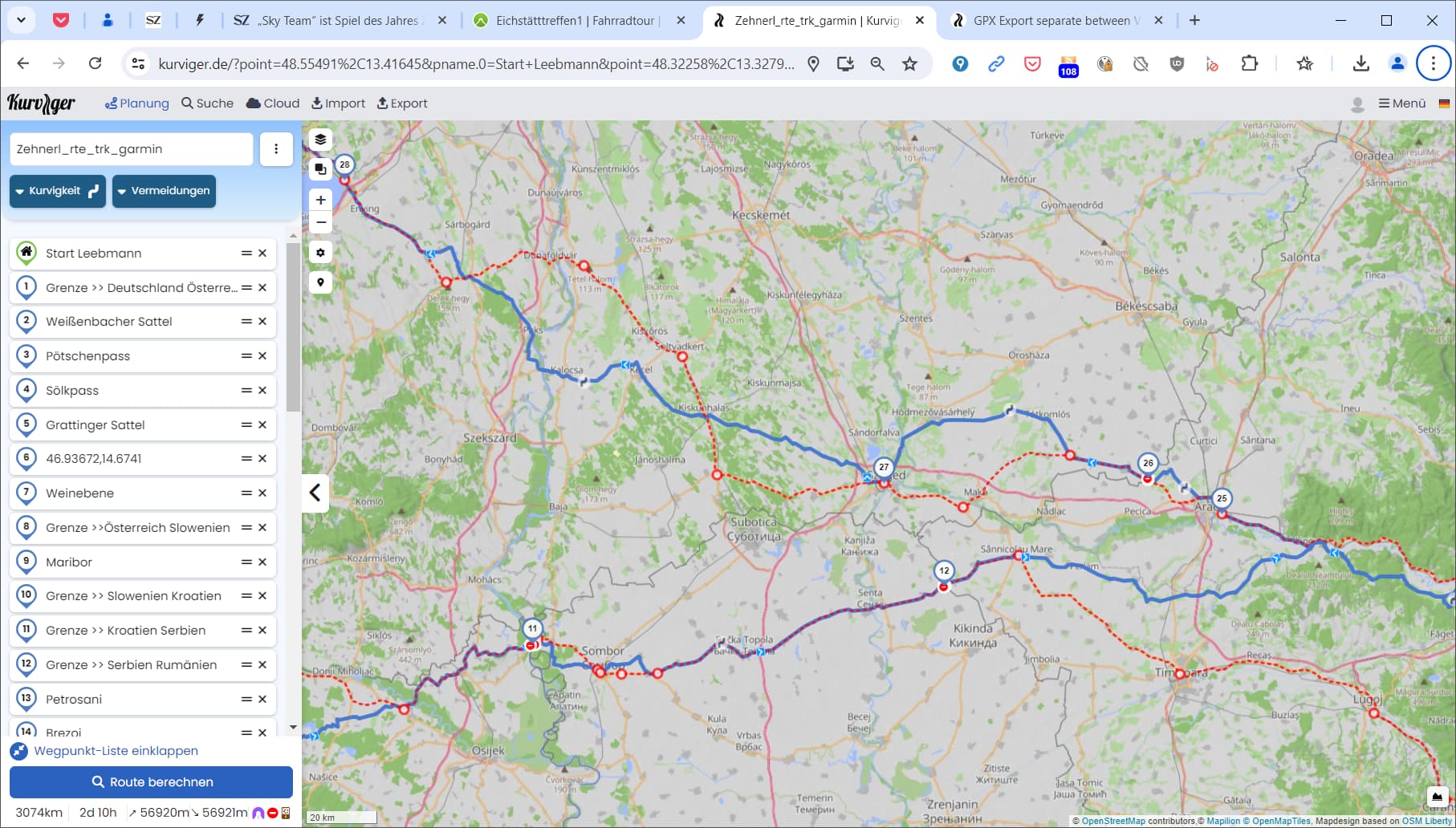
I have planned a tour from Passau to Romania with a total of 96 via and shaping points https://kurv.gr/tDCTs
In order to be able to map a route in the BMW app, I first have to reduce the number of shaping points so that I get a maximum of 50 points. In this case, I only create one track in the BMW app with the original file.
That’s why it would be nice if I could only select the via points for export in the selection, so that I would have all the important points that I can drive to in the BMW app, but I just have to live with the fact that the BMW app uses a different algorithm to guide me to the next via point. (Kurviger isn’t the only one that takes me on great routes from one point to another)
Even if I’m standing in front of a construction site (which isn’t shown in OSM) I quickly switch to the BMW app (Tom Tom) and let it guide me around the construction site to the next waypoint in a relaxed manner and then continue from there with the Kurviger app.
I’m a staunch Kurviger supporter, have the Tourer plus subscription and really enjoy using the app, but I don’t just see everything through Kurviger’s glasses, I also look beyond the box!
Ok, it is a file from Garmin Bootcamp, as far as I can see. I am not sure, if “actually used …” is true in all cases, or if there is a definition or rule at all how to work with waypoints? Yes, it makes sense or is one possibility. I think it mainly depends on the software, which decides how it uses those?
While the export of your Garmin file contains thw waypoints these additional accomodations, the kurviger waypoints contain information about the type like start, destination, shaping point, waypoint what can be used while importing in Kurviger or by other routing software.
I am also curious about the usecase.
The BMW Connected Ride Navigator doesn’t limit waypoints - see BMW Motorrad
But then you have to import the route via cable - see BMW Motorrad
The connection to the smartphone can only be used via the BMW Connected App (with the own BMW ID cloud and the limit of 50 waypoints) - ridiculous.
No - I didn’t test it. Although I own two BMW motorcycles I’ll never use this silly navigation stuff.
Hallo Thorsten,
diese Option funktioniert leider nicht.
Ich habe soeben das mit Deinem Vorschlag exportiert und dann in der BMW App importiert.
Only_WP_Passau Transfagarasan.gpx (61.7 KB)
No, I suggest to use only viapoints while creating the route ![]()
However, as mentioned below by Toffel
it looks like the requested function is already available in the export options - there you can select which point type (via point and/or shaping point) shall be exported.
Gegen meine Erwartung werden die Shaping-Points trotzdem in Wegpunkt-/ und Routenliste übernommen der GPX-Datei übernommen. Es wäre gut, das schaut sich jemand an. Vielleicht gibt es eine Erklärung.
Diese Aussage bestätigt für mich dass Du Dich noch nicht ausreichend mit dem BMW Navigationslösung befasst hast!
Sei bitte so nett und mache Dich kundig und teste es selber!
Die BMW App entscheidet nicht ob ich Via oder Shaping points in der Kurviger Planung verwende.
Beim Import in die BMW App werden alle Punkte in Wegpunkte umgewandelt, und alles was mehr als 50 Punkte sind, wird dann nicht mehr als Route sondern als Track dargestellt!
Der Track ist zwar identisch mit der Kurviger Planung aber es sind keinerlei Wegpunkte ersichtlich!
Wenn ich aber eine Route mit weniger als 50 Punkte habe dann ist jeder Wegpunkt ersichtlich.
Hier kann ich dann ggf. entscheiden mit welchen Parametern ich mich zwischen den Wegpunkten leiten lasse.
Beim Track ist das aber NICHT der Fall.
Das ist es, was Sie vielleicht wollen?
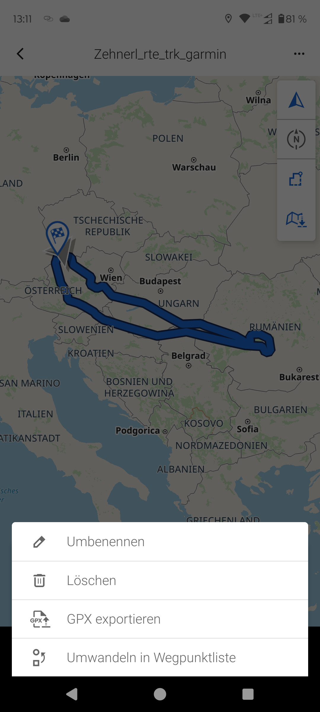
Zehnerl_rte_trk_garmin.gpx (5.4 MB)
EDIT.
Die demodatei (zur Veranschaulichung) wurde mittels notepad ++ edit auf Ihre Bedürfnisse abgestimmt ![]()
[quote=“0709, post:13, topic:17972”]
Das ist es, was Sie vielleicht wollen?
[/q
Ja genau diese Ausführung hätte ich gerne aus der Kurviger App exportieren wollen.
Hier konnte ich in der App mit der Option umwandeln in Wegpunktliste das gewünschte Ergebnis erzielen.
Welche Einstellungen zum Export aus der Kurviger App wurden hier verwendet?
M. W. gibt es keine Export-Einstellung, die zu diesem Ergebnis führt. Vermutlich hat Willy die “rte”-Elemente der shaping points manuell gelöscht.
Daraus ergibt sich jetzt die blaue Route - im Gegensatz zum im Detail ausgetüftelten roten Track - hier ein Ausschnitt, der deutliche Abweichungen beinhaltet:
Es geht hier ja nicht ums zerstören der Route, wenngleich Du recht hast das eine komplett andere Route zwischen den Wegpunkten kreiert wird. (Was aber auch hier nicht gefragt war)
Mir geht’s darum dass ich gerne ein Backup habe und dieses im Fall der Fälle ( Baustelle oder Sperrung) mit dem Backup deutlich einfacher um die Baustelle geroutet werde ohne das ich in der Kurviger App zig mal überspringen drücken muss.( Das hatten wir in der Vergangenheit hier im Forum schon diskutiert)
Der Track in der BMW App funktioniert zwar auch, ist aber nicht so sehr komfortabel wie die Navigation nach Wegpunkten ( Wie gesagt ich nehme die BMW app nur im Notfall her, denn ich bevorzuge ganz klar die Kurviger Navigation, aber in bestimmtem Fällen hat die BMW eben auch Ihre Vorteile.
Hier meine Route aus Kurviger:
Hier der Track aus der BMW App ( bitte diesen als Overlay verwenden)
Leg Dir bitte mal die Kurviger auf den PC und dann die BMW als Overlay drüber dann siehst Du die Vorteile, den das BMW Overlay erkennt hier schon welche Straßen ich aufgrund Sperrungen nicht fahren kann und zeigt mit das jetzt schon an.
Und nun hätte ich eben gerne auch die Möglichkeit mir eine Overlay aus den Wegpunkten der BMW app zu machen, darum habe ich gefragt ob es denn möglich wäre nur die Via Punkte zu exportieren ![]()
Denn bei Garmin gibt’s es ja auch die Möglichkeit im Garmin ShapingPoints GPX Format zu exportieren ( dann denn dann habe ich alle Shaping in Garmin auf “ohne Alarm gestellt”
Ich will auch nicht dass hier nun ein Megaaufwand betrieben wird um meinem Wunsch umzusetzen, aber Fragen dachte ich schadet definitiv nicht vielleicht ist das ja ohne viel Aufwand möglich
In dem Screenshot siehst Du in Rot den Track der BMW App ( Baustellen bereinigt)
Grüße
Peter
Das ist aktuell nicht möglich.
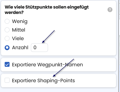
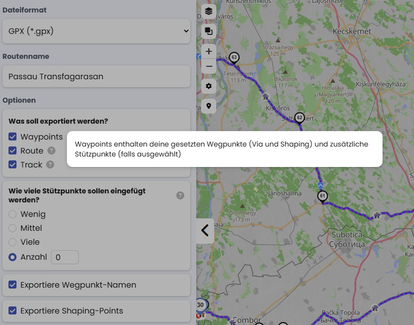
Ja ich glaube hier müssen wir nochmal an die Benamung der Option ran. Die Option erlaubt es dir zu bestimmen ob SP als SP exportiert werden oder eben nur als VP.
Das heißt, wenn ich “Exportiere Shaping-Points” abwähle, werden trotzdem alle Punkte (blau und schwarz) exportiert, nur due schwarzen werden in der Exportdatei mit den blauen gleichgestellt?
Ist der “Stützpunkt” dann das gleiche wie “Shaping-Point”? Wenn ja, dann sollte man überall den gleichen Begriff verwenden. Und wenn man dann welche einfügt (wenig/mittel/viele/≠0), werden die dann auch von der Option “Exportiere Shaping-Points” entsprechend beeinflusst?
Die Benennung der Option ist meiner Meinung nach missverständlich - besser wäre hier “Exportiere Via- / ShapingPoint Information”:
Wenn ausgeschaltet, wird keine Information exportiert - alle Wegpunkte sind standardmäßig ViaPoints.
Wenn eingeschaltet, wird eine Information “ShapingPoint” oder “ViaPoint” exportiert.
In jedem Fall werden alle Kurviger Wegpunkte exportiert.
Definition Wegpunkte bei Kurviger.
Vielleicht noch ein Verbesserungsvorschlag: in den Export-Optionen kann man zwischen “Route” und "Waypoints"wählen. Wenn man aber die Erklärung unter “?” aufruft, kann man den unterschied zwischen den zwei Optionen nicht erkennen:
Es wäre gut, wenn man in der Erklärung unter “?” auch den Unterschied zwischen den Export von der Route und den Waypoints erkennen könnte.